Open Data#
The Open Definition by The Open Knowledge Foundation#
An open work (e.g. piece of knowledge or data) must satisfy the following requirements in its distribution:
Access: The work must be provided as a whole and at no more than a reasonable one-time reproduction cost, and should be downloadable via the Internet without charge.
Machine Readability: The work must be provided in a form readily processable by a computer easy to access and use
Open Format: The work must be provided in an open format (non proprietary), e.g., xml
Open License or Status: The work must be in the public domain (absence of copyright or restrictions) or provided under an open license.
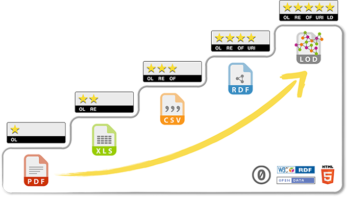
5-star deployment scheme for Open Data#
as suggested by Tim Berners-Lee, the inventor of the Web and Linked Data initiator.

Fig. 2 5 Star deployment scheme#
RDF: language for modelling metadata of online resources, facilitating data exchange without information loss, e.g., reusing or bookmarking data
Online information such as author, title, etc. is identified with uniform resource identifiers (URI)
Source: https://5stardata.info
Open Data is growing#
Try Google’s Data Search Engine.
A small collection of open geospatial data sources is provided below.
How to download spatial data sets or view them in QGIS?#
Download file through web browser
WMS: WebMapService
WFS: WebFeatureService
WMTS: WebMapTileService: uses cached image tiles
WCS: WebCoverageService: raster data that can be used as input for analysis
XYZ Tile service, e.g. OSM
Video Tutorial: Using WMS / WMTS / WFS in QGIS by Digital Geography
Open Data Sources#
Open Data Platforms#
Copernicus Land Monitoring Service - Land cover data
Global Human Settlement Layer - Global data on built-up area and population
Blog#
Open Data Washington DC: also contains nice data stories
Satellite data#
Sentinel-2 imagery from the European Space Agency (ESA)#
Multi-spectral imagery: 13 bands from visible to short wave Infra red
10 to 60 meter resolution (depends on the spectral band)
5 days revisit time
Launched in the end of 2015
Data available at: Copernicus Open Access Hub
Landsat imagery from NASA/ USGS#
Multi-spectral imagery from visible to shortwave Infra red
30 meter resolution
From 1985 (Landsat 5) until now (Landsat 8)
16 days revisit time
Available at:
USGS: Earth Explorer or ESPA
Digital Elevation Models#
Shuttle Radar Topography Mission (SRTM)#
1 arc-second resolution, global coverage
created in 2000, publicly released in2015
Data available at:
EU-DEM from European Environmental Agency#
25m resolution, covering Europe only
Hybrid product of SRTM and ASTER GDEM
Data available at: Copernicus Land Monitoring Service: EU-DEM
OpenDEM#
Contains links to openly available DEM and LIDAR data sets
No global coverage, only regional datasets
Data available at: https://opendem.info/
